
The history of Kimball Avenue is associated with the history of the 1640 Hart House on the corner of Linebrook Rd. and Kimball Avenue. Dendrochronology indicates that the Hart House was actually constructed about 1678. According to the history of the Hart House, displayed in the front entrance, the house remained in the Hart family until 1755, when it was sold to Philip Lord. Philip Lord died in 1816 and willed the property to his daughter Sarah Lord Kimball, who in turn willed it to her son Isaac Kimball. The common ancestors of many of the Kimball family in Ipswich are Richard Kimball Sr. and his wife Ursula Scott of the Parish of Rattlesden, England, who moved to Ipswich in 1635.
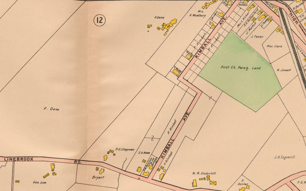
The 1872 map shows the large farm owned by Isaac Kimball stretching from Linebrook Rd. to High Street. In the book, Ipswich Village and the Old Rowley Road, Thomas Franklin Waters wrote that on Nov. 16, 1901, Henry & Josephine Jewett sold Philip Kimball and Gustavus Kinsman four acres of this land, bounded by High Street and land of Philip Kimball (1657:295). They opened up today’s Kimball Avenue between High Street and Linebrook Road, and divided it into house lots. The lots are shown in the “Plan of lots laid out on land of Henry C. Jewett by John W. Nourse in April 1899,” which has not yet been found.
In 1916, the estate of Isaac Kimball sold two properties on Kimball Avenue. In the 1910 map, Philip Kimball owned long empty lots on both sides of the street. Over a period of several years in the early 20th century, Philip Kimball and his wife divided the lots into a subdivision. Kimball Avenue was accepted as a street at the Ipswich Special Town Meeting in September, 1910.
Shown below are screenshots of the deeds listed on the SalemDeeds site. Click to view a larger image

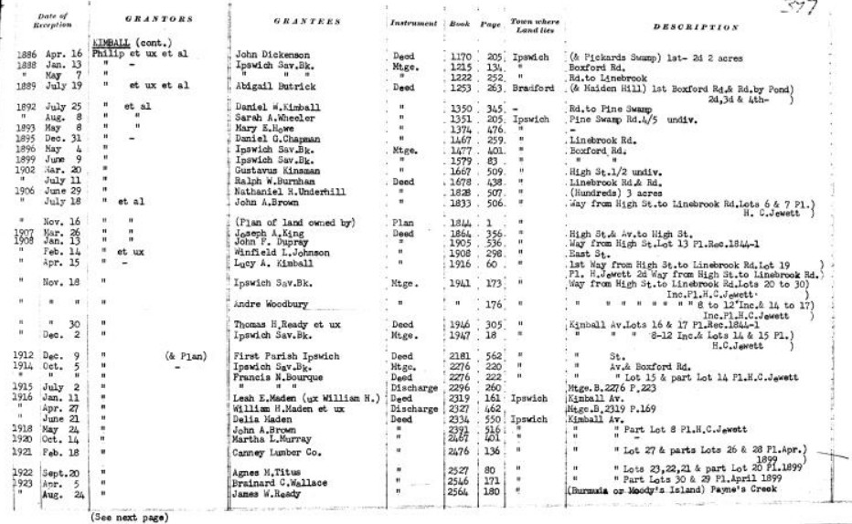
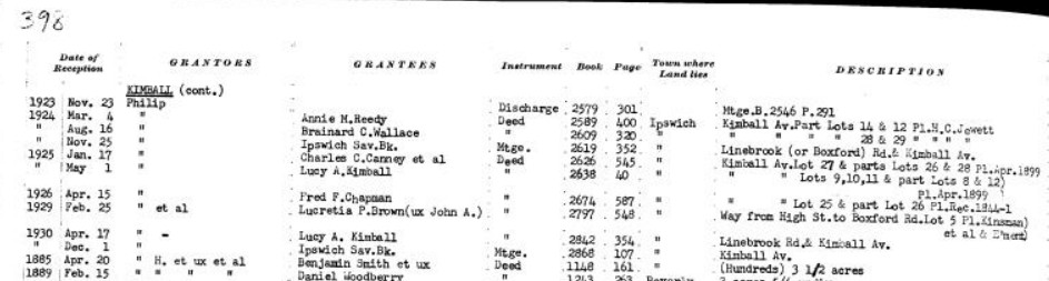
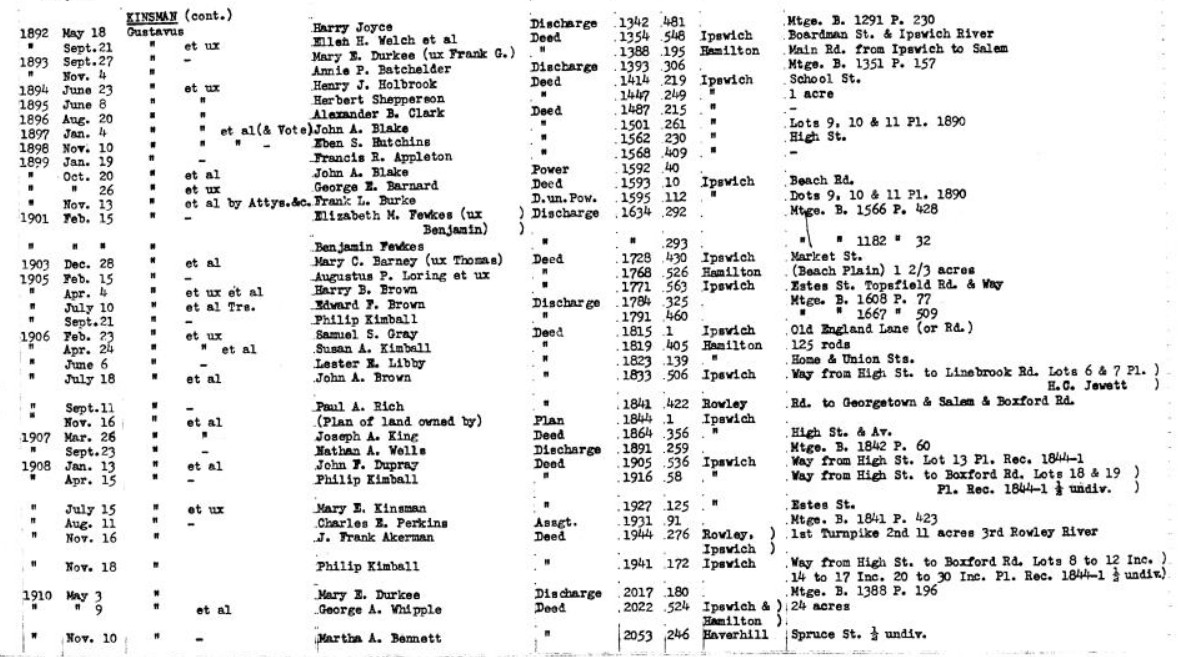
Deeds
Book=2589&page=400: Philip Kimball to Anne Reedy. Lot 12 and part of lot 14. Neighbors are Woodbury southwest, Bourque southeast.
Book=2319&page=161: Philip Kimball to Leah and William Maden. Lot is adjacent to Lucy Kimball. Abutting on land of First Parish Church and Underhill. No lot number given
Book=1946&page=305: Philip Kimball to Thomas & Anne Reedy. Northeast of Woodbury’s lot 15. No lot listed for this sale.
Book=2276&page=222: Philip Kimball to Francis Borque on the northwest side of Kimball Ave. Lot 15 and half of lot 14.
Book=2391&page=516: Philip Kimball to John Brown, beginning at the southeast corner of Kimball Ave. Part of Lot 8.
Book=2467&page=401: Philip Kimball to Martha Murray. Northwest of Howe. No lot # mentioned but part of lot 8.
Book=2476&page=136: Philip Kimball to Canney Lumber. 340 ft southwest of the intersection of Kimball Ave. and High Street. Lot 27 and parts of lots 26 and 28.
Book=2527&page=80: Philip Kimball to Agnes Titus. Southeast side of Kimball Ave. Borders on First Parish land. Lots 21, 22, and 23 with parts of lot 20.
Book=2546&page=171: Philip Kimball to Brainard Wallace. Northeast side of Kimball Ave. Borders on land of Wallace & Ricker. Parts of lots 30 & 29. All of lot 28.
Book=2609&page=320: Philip Kimball to Brainard Wallace. Northwest of Brainards other land. Southeast of Canney land. Parts of lots 28 & 29.
Book=2638&page=40: Philip Kimball to Lucey Ardelle Kimball. Northwest of Ralph Burnham (the Hart House). Northeast of John Brown. Lots 8, 9, 10, 11 & 12. Lot 8 partial previously sold to Reedy, and Lot 12 is partial, previously sold to Brown.
Book=2674&page=587: Philip Kimball to Fred Chapman. 480 ft. southwest of the intersection of Kimball Ave. and High Street. Parts of lots 26 & 25. Borders parts of Parish land.
Book=1833&page=506: Gustafus Kinsman and Philip Kimball to John Brown. Lots 6 & 7 bordering on Woodbury.
Book 1905&page=536: Gustafus Kinsman and Philip Kimball to John Dupray. Lot 13
1920 Census
- #3: John & Nellie Babcock
- #5 Joseph & Addie King
- #6: Clifford & Wanda Bowen
- #12 Nellie Burnham, William Madeau?, Burbridge, Gilmore
- #15: William & Nellie Cates
- #24 Burnham
- #25: Thomas & Anne Reedy, Margaret Rudy, Lemay, Allard

