

- Interactive Google Map of historic houses and places in Ipswich
- Essex County towns in 1643
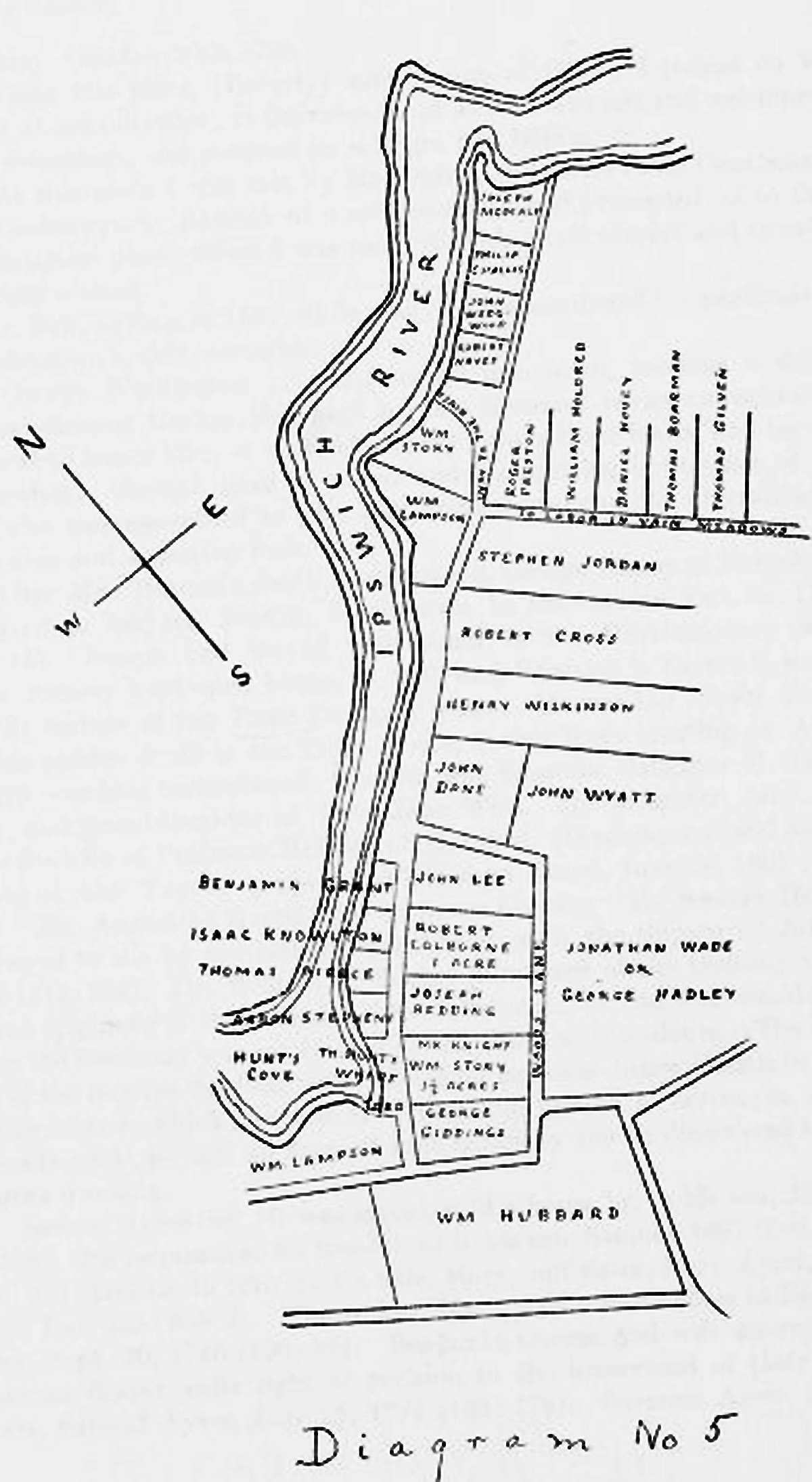
- Maps of 1641 land grants, from Ipswich in the Massachusetts Bay Colony
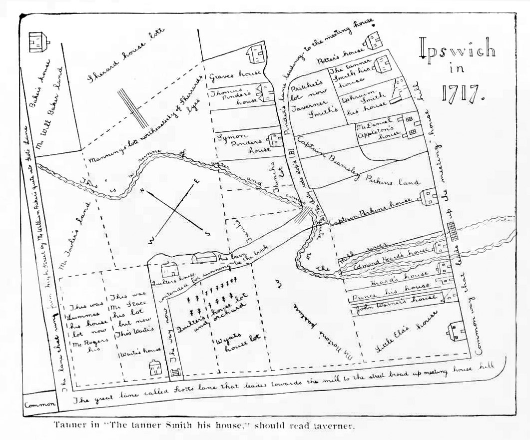
- 1717 Ipswich hand-drawn village map
- Map 1
- Map 1 inscription
- Map 2
- Ipswich in 1717 (MVB Perley)
- 1795 Plan of Ipswich by Barnabas Dodge
- 1832 Philander map of Ipswich village (large file, good resolution, printable)
- 1832 Philander town map at Digital Commonwealth (online, scroll in for high resolution )
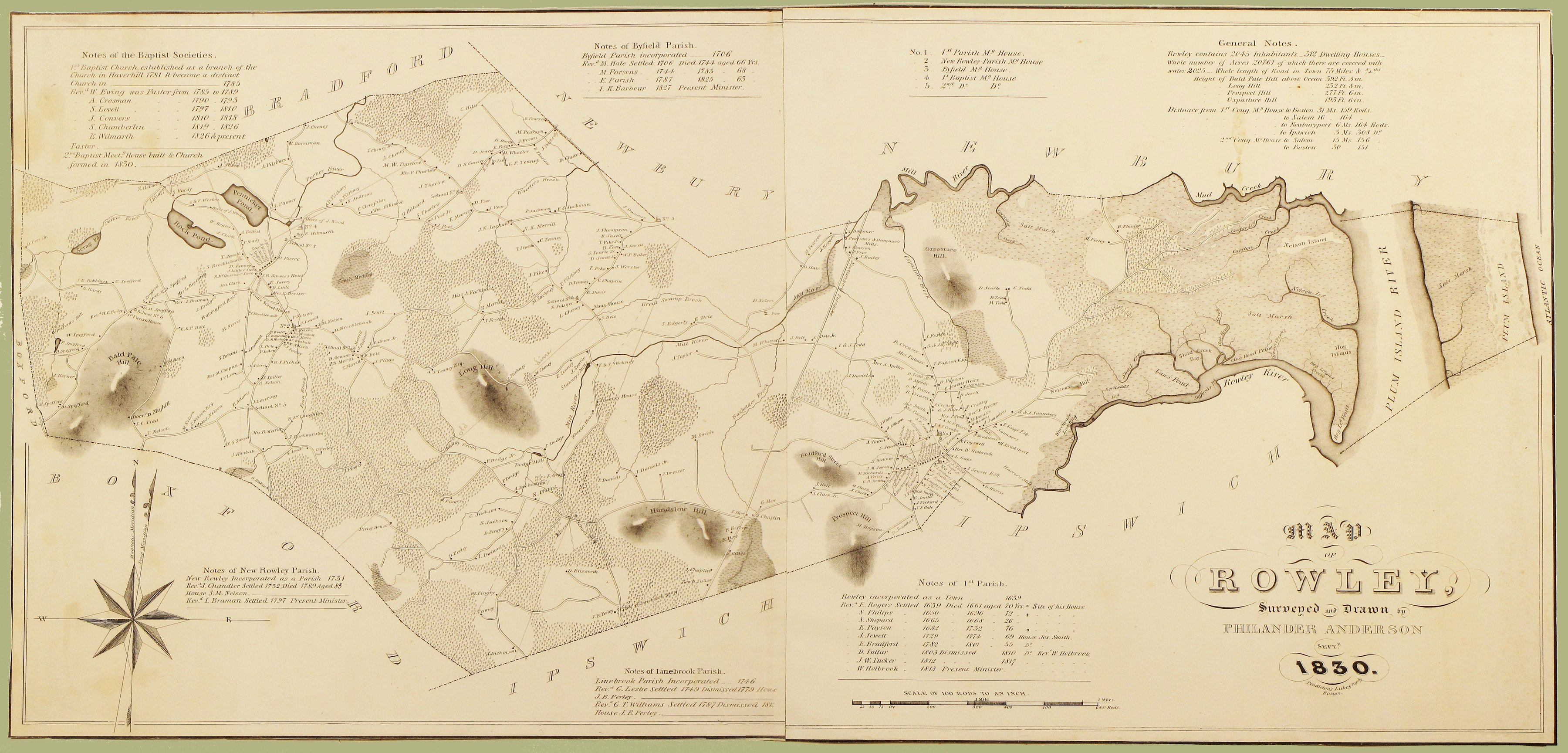
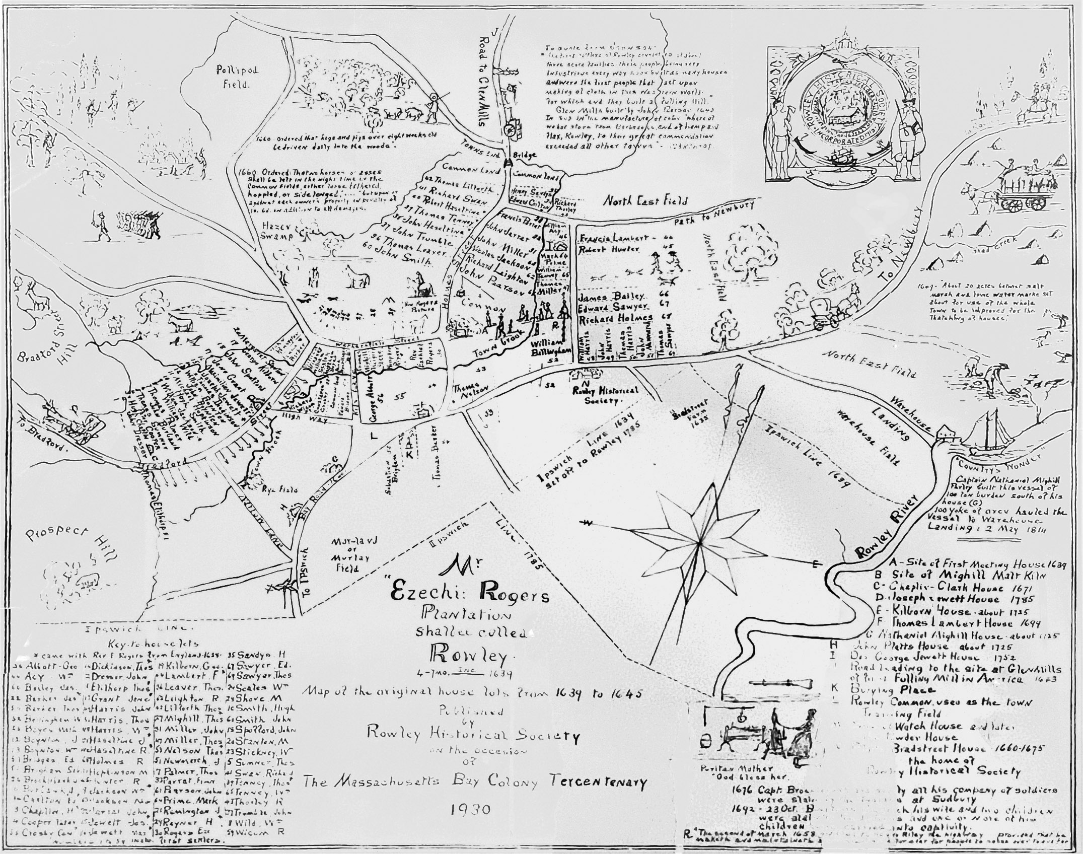
- 1840 map of Rowley
- 1856 Essex County and town map interactive)
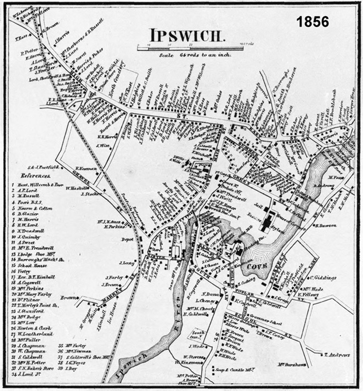
- 1856 Ipswich village map (jpg printable)
- 1872 Ipswich town map (jpg printable)
- 1872 Ipswich village map (jpg printable) at Digital Depository
- 1872 Ipswich center map (this site)
- 1872 Town of Ipswich map at Ward Maps
- 1872 Ipswich Center map at Ward Maps
- 1872 Ipswich center at Old Maps.com
- Ipswich, Massachusetts 1884 (Ward Maps)
- 1884 Ipswich Center, (Ward Maps)
- 1884 Ipswich Center, large file, good resolution
- 1893 Ipswich village birdseye map (jpg printable)
- 1893 Ipswich birdseye map, very high resolution (online, scroll in for high resolution)
- 1887 Sanborn fire insurance maps of Ipswich (in 8 sections) at the Library of Congress
- 1892 Sanborn fire insurance maps of Ipswich (in 5 sections) at the Library of Congress
- 1902 Sanborn fire insurance maps of Ipswich (in 5 sections) at the Library of Congress
- 1907 Sanborn fire insurance maps of Ipswich (in 12 sections) at the Library of Congress
- 1916 Sanborn fire insurance maps of Ipswich (in 11 sections) at the Library of Congress
- 1910 Ipswich Center (large file)
- 1910 Ipswich Village section maps (Historic Map Works)
- 1910 Ipswich Village section maps (Flickr)
- 1910 Atlas of the towns of Topsfield, Ipswich, Essex, Hamilton, and Wenham, Essex County, Massachusetts at the Library of Congress
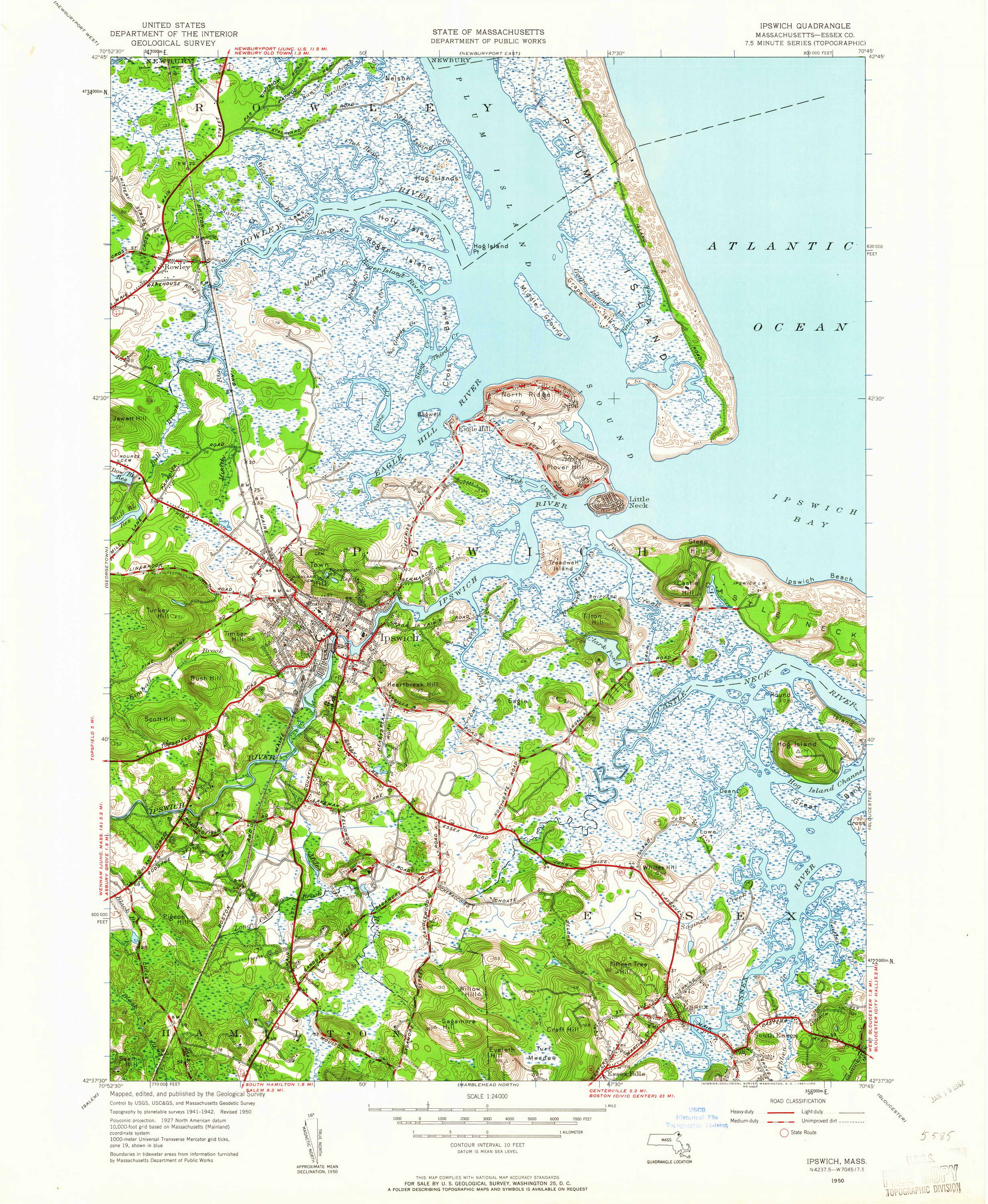
- 1950 Geological Survey of Ipswich, MA
Sanborn Insurance Maps
- Sanborn Fire Insurance Map from Ipswich, Essex County, Massachusetts. Oct 1887. 4 sheet(s). Date: 1887-10. View All Images
- Sanborn Fire Insurance Map from Ipswich, Essex County, Massachusetts. Jul 1892. 5 sheet(s). Date: 1892-07. View All Images
- Sanborn Fire Insurance Map from Ipswich, Essex County, Massachusetts. Jan 1897. 6 sheet(s). Date: 1897-01. View All Images
- Sanborn Fire Insurance Map from Ipswich, Essex County, Massachusetts. Dec 1902. 8 sheet(s). Date: 1902-12. View All Images
- Sanborn Fire Insurance Map from Ipswich, Essex County, Massachusetts. May 1907. 12 sheet(s) Date: 1907-05. View All Images
- Sanborn Fire Insurance Map from Ipswich, Essex County, Massachusetts. Apr 1916. 11 sheet(s). Date: 1916-04. View All Images
Rowley

Hi there. I came across a letter from a woman named Annie Whitcomb, dated March 18, 1911 on letterhead from the Restview Fruit Farm in Ipswich that was associated with Oliver C. and William H. Whitcomb. She appears to be addressing being left out of a will and goes on for four pages about the circumstances. I’m not able to find a record of the farm and am wondering if the 1910 map may have information related to the Whitcombs or the fruit farm. The envelope has a fancy return design for the farm — which featured pears, apples, plums, peaches with Baldwin apples and Golden Russets a Speciality. I live in Ipswich so not sure if it’s easier to come in and look at a map. Thank you
Sorry, there’s no record of a Restview Farm, nor any record of the surname Whitcomb in Ipswich, Massachusets. According to the Essex County Deeds site there were many Whitcombs in other Essex County towns, especially Haverhill. A prominent family in Ipswich was Willcomb, also spelled Wilcomb. The only orchard I am aware of at that time that would have had that variety of apples was Goodale Orchard on Argilla Rd., which is today called Russell Orchards. Could it have been Ipswich, England? There is a link to each section of the 1910 Ipswich map on this page, https://historicipswich.net/maps-of-historic-ipswich/