
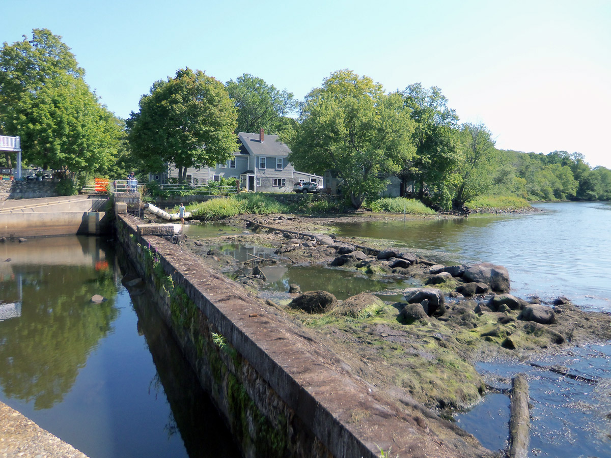
Geologically, the Ipswich River is quite young. The Laurentide ice sheet during the most recent ice age receded to the northern border of Massachusetts around 14,000 years ago. As the ice sheet melted, the sea level rose about 100 ft. higher than current levels, putting much of the North Shore area temporarily under water until the land, which had been lowered by the weight of the glaciers, began to rebound about 12,000 years ago. The drumlins, moraines, and eskers the glaciers left dictate much of the course of the river until it encounters the foot of Town Hill in Ipswich, metamorphic rock that is believed to have drifted to this location hundreds of millions of years ago. The river follows a minor geological fault past the Town Landing and enters the ocean between two glacial drumlins, Little Neck, and Steep Hill.

Until 350 years ago, the Ipswich River ran unencumbered by man-made dams from its origin 35 miles upstream, carving its way through a 148-square-mile watershed. Herring, shad, salmon, and alewife swam upstream to spawn. Ipswich historian Thomas Franklin Waters wrote, “Great shoals of alewives came up the river in the Spring and were seined at night by the light of torches under the arches of the old Stone Bridge. A line of dories intercepted their passage over the dam at the footbridge, and great quantities were taken with a dip net.”
As dams were built, migration of fish along the river diminished and has now all but ended. Construction of fish ladders at the present Ipswich Mills dam at EBSCO has had little or no effect.


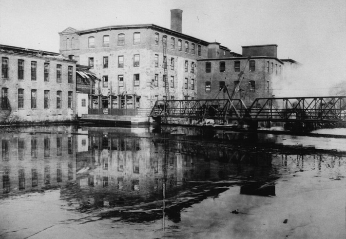
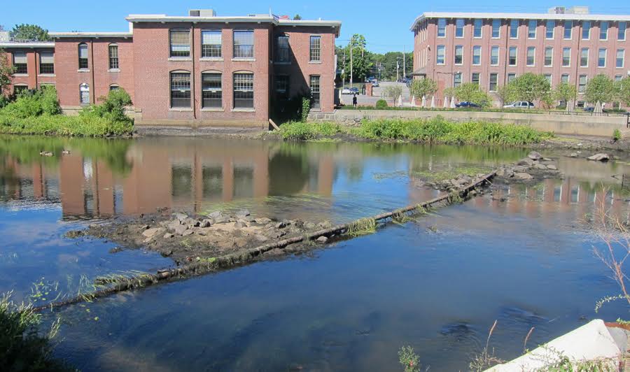
A dam has existed in the vicinity of the Ipswich Mills Dam site since 1637. The current dam was built in the early 19th century and was modified in 1908, increasing its structural design in order to supply the mill with a reliable source of power. The dam no longer serves its industrial purpose. The Ipswich River Watershed Association has conducted a preliminary study that will help determine the feasibility of removing the dam.

The following article was written by John Stump in 2011 for a presentation at the Ipswich Museum
“The origins of a dam at the location we today call the EBSCO Dam in Ipswich can be traced back to 1635. Before the first dam was built here, there was a set of natural waterfalls that are referred to as the Upper Falls. These falls made an ideal location for a dam. (The Lower Falls are located just below the County Street Bridge and can be seen easily today.) This early dam was the first ever built on the Ipswich River by English colonists and was located approximately 30 feet above today’s present dam.


“The reason for this early dam’s construction was to provide water power for a gristmill located on the north side of the river. Richard Saltonstall built and owned the gristmill at the relatively young age of 25, after arriving in New England with his father Sir Richard Saltonstall only 5 years earlier. This was the only gristmill in Ipswich until 1687 and the only one on the Ipswich River until 1697, thus giving the Saltonstall family a complete monopoly of this very necessary and important business. The Saltonstall family held a financial interest in this mill site until 1729. This early dam was most likely built of logs and stones strategically placed on the Upper Falls and would need constant attention and maintenance.
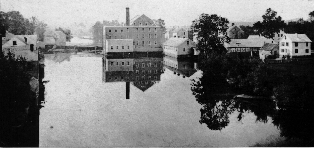

“The name “Mill Garden” was given to this area due to the numerous types of mills located there throughout the years. At different times, there were gristmills, fulling mills, dye houses, sawmills, bark mills, tanneries, and as early as 1657, a hemp mill. A sawmill can be documented in operation on the south side of the river next to the Dam in 1729. By 1792, Asa Andrews was operating it, along with a scythe mill. In 1796 Mr. Andrews was appointed to the prestigious and important capacity of being the first Customs House Collector of the Port of Ipswich where he served for 33 years.
“By the 1830s Benjamin Hoyt was operating a sawmill here and on October 1, 1843, he signed a 10-year lease, at a cost of $100 annually, for the right to build and operate a new sawmill. The lease also allowed the rights to water power. The sawmill is believed to have been in operation until 1858 when the building was moved to a new location at 17 County St. The owners of the dam would maintain it and lease water power to the businesses that used it.
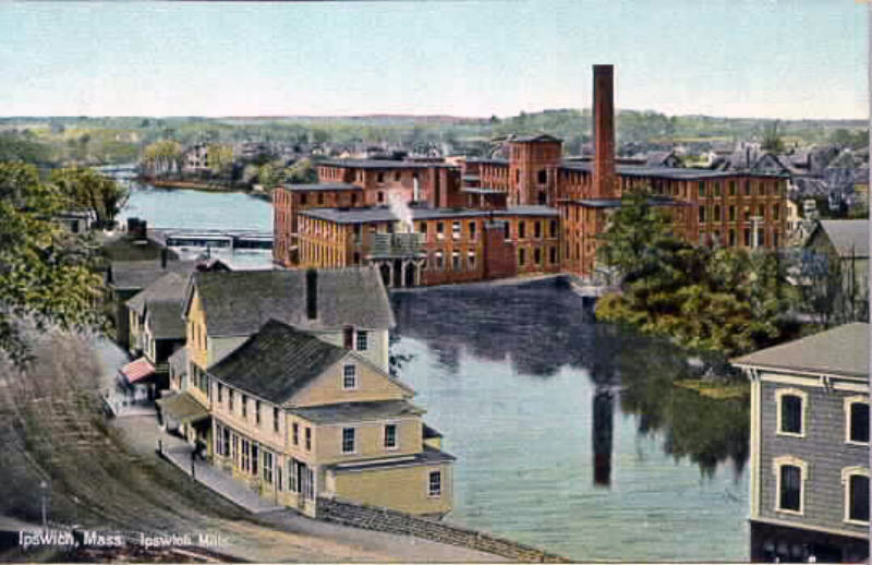
“It was not until 1827 that we know of a substantial stone dam built at today’s location. It was built for the Ipswich Manufacturing Company, consisting of Joseph Farley and brothers George and Augustine Heard to power a stone textile mill that would be located on the north side of the river and would manufacture cotton cloth. This was the first time water power had ever been used in Ipswich to produce cloth. At this time the ancient ford-way that went across the river below the dam was closed and no longer used.

“The height of the dam could be adjusted with the addition of wooden flashboards attached to the top of the stone. In 1830, 12″ flashboards were added to the top of the dam, and by 1858 the flashboards had been raised to 18”. Due to the higher flashboards, properties upriver were being flooded and Augustine Heard, who owned the dam at this time, was compensating them financially for the loss of their lands. In 1846 the Dane Manufacturing Company purchased the business, but not the dam, for $24,000 and continued to operate at this site, making a coarse cotton cloth called drilling.
“Amos Lawrence purchased the mill and its associated properties on January 16th, 1868 for $70,000. It was then renamed The Ipswich Mills Company and began the production of hosiery instead of cotton cloth. The Ipswich Hosiery Mill was in operation until 1928 and at one time was the largest stocking mill in the country.
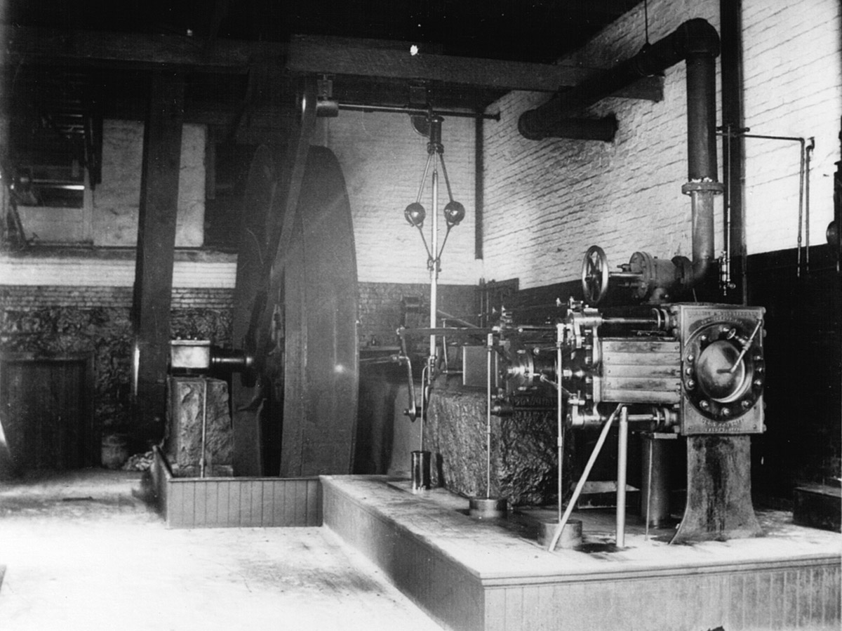
“In 1941 Sylvania purchased the mill buildings, as well as the dam, where they produced various products including proximity fuses, military and commercial transformers, and tungsten coils. EBSCO Publishing bought the remaining buildings along the river in October of 1995 from Osram Sylvania and moved in July 1996 after renovations were completed.

“The present dam is believed to have been rebuilt around 1880. The technique used to cut the stone as well as the size of the stones are the primary basis for this assumption, as well as 2 maps showing different shaped dams. There is a record of additional work being completed in 1908. Rebuilding was most likely driven by large maintenance costs as it fell into greater degrees of disrepair.
“The average size of the stones today is approximately 6 feet wide x 20 inches tall and four feet deep, weighing on average approximately 5,000 pounds. In 1982 the Town of Ipswich purchased the dam from GTE Sylvania and today the Ipswich Utilities Department is responsible for its maintenance.”

Sources and further reading:
- The Textile Industry, Chapter XXVII, Ipswich in the Massachusetts Bay Colony, Vol II, by Thomas Franklin Waters
- Ipswich Mills and Factories
- Along the Ipswich River, 1860-1930
- Ipswich dam summary report pal draft, June 29, 2016
- Expanded Environmental Notification Form for the Ipswich Mills Dam Removal, October 16, 2023
- IpswichMillsDam.com
 No “Bait and Switch” - Photo by David “Stoney” Stone Letter: The headline “Bait and Switch” in the November 25 article about the Ipswich Mills Dam was eye-catching but very misleading. Read this article at the Ipswich Local News.
 Historic Survey of the Ipswich Mills Dam - Inventory No: IPS.9009: Ipswich Mills Hosiery Manufacturing Company Dam. Survey Form F (structure) submitted to the Massachusetts Historical Commission, Recorded by: Ted Dattilo for the Public Archaeology Laboratory, Inc., May 2024. Received by the Mass. Historical Commission on Nov. 12, 2024 Historical Narrative: The history of the dam and how it relates to the development… Continue reading Historic Survey of the Ipswich Mills Dam
  Ipswich Receives $1.2M Grant For Dam Removal - Ipswich Mills Dam Removal Project Nationally Recognized Among 43 Projects to Receive U.S. Fish and Wildlife Service Funding On April 23, 2024, the U.S. Fish and Wildlife Service announced that 29 states will receive just over $70 million to support 43 projects that will address outdated or obsolete dams, culverts, levees, and other barriers fragmenting… Continue reading Ipswich Receives $1.2M Grant For Dam Removal
  Ipswich Mills Dam Feasibility Study - In 2010, the Ipswich Board of Selectmen voted to begin exploring removal of the Ipswich Mills Dam. The feasibility study was completed in March, 2019 and will set the stage for the Town's decision regarding the dam.… Continue reading Ipswich Mills Dam Feasibility Study
 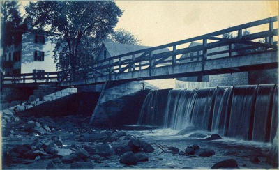 The History of the Ipswich Mill Dam, and a Natural History of the Ipswich River - We measure history by time, but for the Ipswich River and its alewives, time could be running out. We can help preserve the human and natural history of the Ipswich River by freeing it from its man-made encumbrances.… Continue reading The History of the Ipswich Mill Dam, and a Natural History of the Ipswich River
  Regarding the Removal of the Ipswich Mills Dam - By Ipswich resident Roger Wheeler On May 21, a yes vote to remove the head of tide Ipswich Mills Dam and free the river will provide Ipswich, Essex County, and New England with a rare fish-accessible river. This could be an extraordinarily uncommon river and watershed if all fish have accessibility at the head of… Continue reading Regarding the Removal of the Ipswich Mills Dam
  The Miles River - Known in Colonial times as Mile Brook, the Miles River is a major tributary of the Ipswich River but has been diminished in volume by upstream use as a water supply. Evidence of the old Potter and Appleton mills can still be found near County Rd.… Continue reading The Miles River
  The Choate Bridge - The American Society of Civil Engineers cites the Choate Bridge in Ipswich as the oldest documented two-span masonry arch bridge in the U.S., and the oldest extant bridge in Massachusetts. … Continue reading The Choate Bridge
 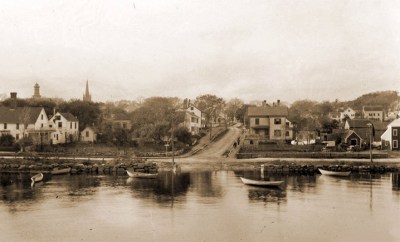 When Herring Were Caught by Torchlight - In the late 19th Century, most of the men around the river would look forward to "herringing" when fall arrived. The foot of Summer Street was the best landing. One year so many herring were caught, they were dumped in the Parker River, and Herring did not return for many years.… Continue reading When Herring Were Caught by Torchlight
  Massachusetts Provincial Law: “An Act to Prevent the Destruction of Alewives on the Ipswich River” - Concerns about the environmental toll that dams have on the Ipswich River date to before 1773. … Continue reading Massachusetts Provincial Law: “An Act to Prevent the Destruction of Alewives on the Ipswich River”
  Industrial History of the Ipswich River - The Industrial History of the Ipswich River was produced for the Ipswich 375th Anniversary by John Stump, , and Alan Pearsall.Historic photos are by Ipswich photographer George Dexter. … Continue reading Industrial History of the Ipswich River
 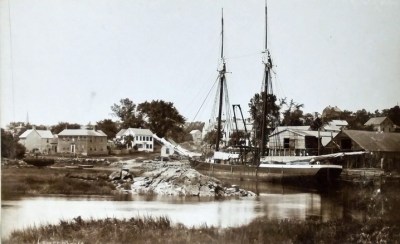 The Town Wharf - The Ipswich Town Landing is one of several locations along the River where wharves were located over the centuries. … Continue reading The Town Wharf Along the Ipswich River - Historic photos of the Ipswich River from original glass negatives taken by early Ipswich photographers Arthur Wesley Dow, George Dexter and Edward L. Darling. … Continue reading Along the Ipswich River
 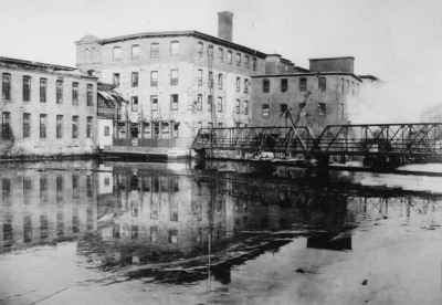 A Photographic History of the Ipswich Mills Dam - Geologically, the Ipswich River is quite young. The Laurentide ice sheet during the most recent ice age receded to the northern border of Massachusetts around 14,000 years ago. As the ice sheet melted, the sea level rose about 100 ft. higher than current levels, putting much of the North Shore area temporarily under water until… Continue reading A Photographic History of the Ipswich Mills Dam