

The Essex County Trail Association maintains an interactive map of conservation areas and other hiking trails in Essex County. The Essex County Greenbelt is a regional land trust that has protected over 15,000 acres of land in Essex County, including the following areas accessible to the public. The Trustees of Reservations own several properties in Ipswich with miles of trails. The Ipswich Open Space program includes several properties with trails. The state owns hundreds of acres of open land in Ipswich and the surrounding area, including Willowdale State Forest, Bradley Palmer State Park, and Sandy Point State Reservation.
View an interactive map of Ipswich Trails
Ipswich
Appleton Farms, County Rd. Ipswich. Trails from the Visitor Center connect with Appleton Farms Grass Rides in Hamilton. Appleton Farms trail map
Bay Circuit Trail, Boxford, Ipswich, Rowley, Newbury, Newburyport. Trail map for the Ipswich-Rowley section of the Bay Circuit Trail
Bradley Palmer State Park, Topsfield Rd., Ipswich, Winthrop Rd. Hamilton, Asbury St., Topsfield. Download the Willowdale and Bradley Palmer trail map. Download the Trail map for Bradley Palmer SP.
Crane Beach and Castle Neck, Argilla Rd. Ipswich. Over 6 miles of trails through the dunes and around the Castle, plus several miles of beach to walk on. Castle Hill area trail map
Daniel Boone Park, Top of Spring Street on Town Hill in Ipswich.
Dow Brook Conservation Area, Dow/Bull Brook Reservoirs, High St., Ipswich. A three-mile hike begins at Veterans Recreational Field on Mile Lane near Linebrook Road in Ipswich or near White Farms Ice Cream on High St.
Elizabeth How Reservation. Near Hood Pond and the western end of Linebrook Rd.
Hamlin Reservation, Argilla Rd., Ipswich. A mile-long trail takes you to a wooded coastal island.
Hood Pond, Linebrook Rd., Ipswich. 100-acre pond crossed by the Bay Circuit Trail, Massachusetts Department of Conservation & Recreation.
Julia Bird Reservation, Waldingfield Rd., Ipswich, adjacent to Appleton Farm, is part of an extensive network of protected open space along the Ipswich River.
Linebrook Woods Conservation Area, 275 Linebrook Rd., Ipswich, next to Marini Farms. A 78-acre parcel of wooded uplands and wetlands, with trails extending north to the town watershed lands trail network, and to the south into Willowdale State Forest.
New England Biolabs trails, Public trails in the former Proctor Estate along the Miles River.
Nichols Field, 60 Labor in Vain Rd., Ipswich. A 15-acre parcel of open fields and woods adjacent to the Ipswich River.
Riverbend, Ipswich River Watershed Association. Trail loop from the headquarters down to the Ipswich River.
Ross Property, Open Space program property off of Paradise Rd., Ipswich.
Sally Weatherall Saltmarsh & Viewing Platform
Sandy Point State Reservation, Plum Island (accessible by Newburyport). Located at the southern tip of Plum Island, Sandy Point stretches 77 acres. It features a beautiful coastal beach, great for swimming and sunbathing.
Shady Creek Conservation Area, Colonial Acres, Topsfield Rd. Located at the end of the cul-de-sac on Colonial Drive, a 44-acre parcel of wooded uplands and wetlands along the Ipswich River. This area has limited trail access and no river access.
Sidney Shurcliff River Walk, Ipswich. A pleasant short walk along the Ipswich River from the County St. bridge to Town Hall at Water St.
Steep Hill and Cedar Point, Crane Estate, Argilla Rd.
Strawberry Hill, Jeffreys Neck Rd., Ipswich. Located at 56 Jeffreys Neck Road, a 91-acre parcel of open fields and marsh adjacent to the Eagle Hill River. Across Jeffreys Neck Road from The Trustees of Reservations’ Greenwood Farms property is also open to the public.
Willowdale Meadow. Topsfield Rd., Ipswich. One of several starting points for walks through Willowdale State Forest East. The property is an old meadow with some single-track
Willowdale State Forest has 40 miles of trails. The East side on Topsfield and Linebrook Rd. connects to Hood Pond, Willowdale West.
Andover
Harold Parker State Forest. Miles of trails and mountain biking between Middleton and Andover.
Ward Reservation, Prospect Road, Andover, and North Andover. Almost 10 miles of trails, easy-to-moderate hiking, and strenuous in places. Some of the trails here are part of the Bay Circuit Trail.
Weir Hill, Stevens Street, North Andover. Four miles of trails with vistas of both scenic Lake Cochichewick and the broader landscape of the Merrimack Valley.
Essex
Cox Reservation, 82 Eastern Avenue, Essex. Stunning views of a breathtaking tidal estuary in the Great Marsh ecosystem.
Stavros Reservation, Island Rd., Essex. This reservation protects more than 50 acres of salt marsh. A loop trail leads you along a field and up the hillside to a broad, open meadow. Here stands the fieldstone base of a 50-foot, three-level tower.
Gloucester
Ravenswood Park, 481 Western Avenue (Route 127), Gloucester. 10 miles of trails and former carriage roads. Moderate hiking. Carriage roads are covered with dense crushed stone and are generally wheelchair accessible.
Halibut Point Reservation. 2.5 miles of trails with weather-beaten bluffs, ocean views, and a low rocky coastal shelf.
Dogtown Commons, Cherry St., Gloucester, MA. Five square miles of abandoned settlement in a glacial rock field.
Hamilton
Appleton Farms Grass Rides, Highland Ave., Hamilton. Miles of carriage trails abutting Appleton Farms and Harvard Forest.
Discover Hamilton Trail, which includes part of the Bay Circuit Trail, runs from Bradley Palmer State Park through the Pingrey Estate, Appleton Farms, and Harvard Forest.
Harvard Forest, Cutler Rd. The Harvard Forest Recreation Ground is owned by Harvard University. It is 116 acres. This property is open to the public. The property has 1.7 miles of public trails.
Pingree Reservation, Cutler Rd. This 136-acre property has wide paths interconnected by single track and is a part of the Bay Circuit Trail and the Discover Hamilton Trail, connecting to Harvard Woods
Donovan – Sagamore Trail, Sagamore St., Hamilton. The Donovan/Sagamore Hill Trail connects the Donovan ballfield area with Sagamore Street via the Donovan Woods and Donovan Hill. The southern half of the trail is located on public lands owned by the Town of Hamilton. The northern half of the trail is a public trail easement that crosses through private properties. The single-track trail is mostly wooded and the terrain is relatively steep on either side of the hill.
Manchester by the Sea
Agassiz Rock. School Street, Manchester, a Trustees of Reservations property. Moderate climb to some unusual boulders overlooking Cape Ann. 1.5-mile loop trail (moderate hiking) takes in both Big and Little Agassiz Rocks.
Coolidge Reservation, Rt. 127, Manchester-by-the-Sea. A one-mile trail runs from the parking area to the top of Bungalow Hill, around Clarke Pond to Magnolia Beach, and to the Ocean Lawn.
Newbury, Newburyport, and West Newbury
Brake Hill and Groveland Town Forest, Rt. Rt. 113, West Newbury. The highest point in West Newbury (Elev. 258′). Parking is available along the street near 19 Hill Top Circle or on Brake Hill Terrace near Route 113.
Chestnut Hill Farm, Farm Rd., West Newbury. Loop trail through farmland to the Merrimack River, easy walking on grass pathways with river views from the overlook. The parking lot is located at the end of Farm Lane.
Crane Pond Wildlife Management Area, Bear Hill Road, Groveland. Multiple parking areas in Groveland (Little Road, Bear Hill Rd), Newbury (Moody St), and Georgetown (Little Rd). In West Newbury, parking is available at the end of Georgetown Road near the Groveland town line.
Indian Hill Reservoir, West Newbury. Level roadway and trail around the reservoir. Connects to Indian Hill Farm.
Little River Nature Trail, High St., Newburyport. A rich wildlife habitat, a 5-mile trail surrounded by an urban setting. Easy terrain, including meadows, forests, vernal pools, and wetlands.
Martin Burns Wildlife Management Area, Orchard St., Newbury, MA.
Maudslay State Park, 74 Curzon Mill Road, Newburyport. Former estate with over 400 acres of parkland owned by the state along the Merrimack River.
Old Town Hill, Newman Rd., Newbury. A three-mile network of trails and pathways leads you along the Parker River and a ridge with scenic views.
Parker River National Wildlife Refuge Hell Cat Trail, Plum Island. This boardwalk trail is divided into the 0.6-mile Dunes Trail and the 0.8-mile Marsh Trail.
Riverbend Conservation Area, adjoining Maudslay SP, Newburyport. Riverbend Conservation Area trail map
Rowley
Hunsley Hills, Rt. 133, Rowley. A 1-mile loop trail that offers the chance to see wildlife and is good for hiking, walking, and nature trips.
Prospect Hill Conservation Area, Rt. 133, Rowley. Part of the Bay Circuit Trail, it connects to Dow and Bull Brook Conservation, Linebrook Conservation, and Willowdale State Forest.
Topsfield
Bare Hill Park, Rt. 97, Topsfield.
Ipswich River Wildlife Sanctuary, 87 Perkins Row, Topsfield. 12 miles of trails invite you to explore the forests, meadows, wetlands, drumlins, and eskers. You can also travel down the namesake river,
Topsfield Linear Common. Start Downtown Topsfield, approximately 4 miles long, connecting to sections of the Border to Boston trail in Wenham, Danvers, and Beverly, and north to the Boxford town line.
Topsfield Town Forest, Rt. 97 at Hood Pond.
Grand Wenham Canal, connects with a side trail on the Topsfield Linear Common and Ipswich River.
Wenham
Cedar Pond, Rt. 97, Wenham. The wildlife sanctuary contains approximately 110 acres of upland forest.
Chebacco Woods, 255 Grapevine Rd, Wenham. The Gordon College trails vary from easy flat dirt roads to singletracks.
J.C. Phillips Nature Preserve, 85 acres. The Phillips family continued to live on the property, with his sons purchasing adjoining properties and expanding Moraine Farm. The Nature Preserve is now jointly managed by the Trustees of Reservations and the Essex County Greenbelt. J. C.
Posts
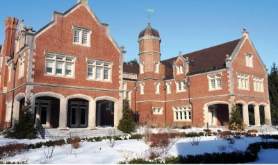 240 County Road, the Proctor Estate, New England Biolabs (1895) - The former James H. Proctor estate was built in 1895. The Catholic Church purchased the property, where it was used as a novitiate by the Oblates of Mary Immaculate, and later became the Catholic school Don Bosco. Since 1999 the Proctor estate has been the home of New England Biolabs, which provides walking trails open to the public.… Continue reading 240 County Road, the Proctor Estate, New England Biolabs (1895)
 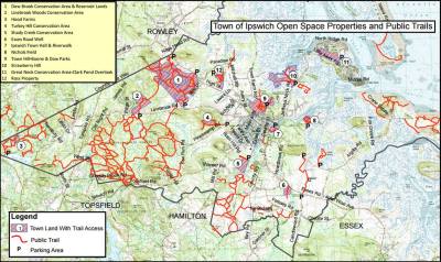 Ipswich Open Spaces - Town meetings in Ipswich have voted to protect hundreds of acres of land, through the Open Space Program, making it available for the general public and preserving the land from development. … Continue reading Ipswich Open Spaces
  Appleton Farms - Owned by the Trustees of Reservations, Appleton Farms is America’s oldest working farm, with 12 miles of walking trails, a visitor center, and Community Supported Agriculture program.… Continue reading Appleton Farms
  Dow Brook and Bull Brook - Bull Brook originates in Willowdale, crosses Linebrook Rd. and merges with Dow Brook at the Ipswich Utilities site on Rt. 1A. From that point the combined stream becomes the Egypt River.… Continue reading Dow Brook and Bull Brook
 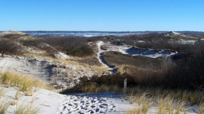 Winter Walks in the Dunes at Castle Neck - Crane Beach and all of Castle Neck are protected by the Trustees of Reservations. Pitch pine and scrub oak rise from the masses of marsh grass, sage green hudsonia and dune lichen lining the trails that wind through the dunes.… Continue reading Winter Walks in the Dunes at Castle Neck
  The Farm at Wigwam Hill - Symonds Epes bought a large tract in 1726 and built a substantial farm and orchards at Wigwam Hill, named for a group of destitute Indians who briefly camped there. The protecting pitch pines were later cut for lumber, and the farm became a large dune.… Continue reading The Farm at Wigwam Hill
 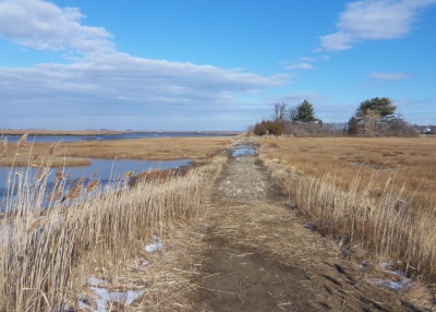 Strawberry Hill and Greenwood Farm - The landscape surrounding Strawberry Hill on Jeffreys Neck Rd. invokes a time when saltwater farms were common in Ipswich. Across the street is Greenwood Farm and the First Period Payne House, owned by the Trustees of Reservations. … Continue reading Strawberry Hill and Greenwood Farm
  Destination Topsfield: Mass Audubon’s Ipswich River Wildlife Sanctuary - Massachusetts Audubon's Ipswich River Wildlife Sanctuary at 87 Perkins Row in Topsfield has miles of trails weave through an amazing mix of forests, meadows, and wetlands, with beautiful views of the Ipswich River from an observatory and two glacial eskers. … Continue reading Destination Topsfield: Mass Audubon’s Ipswich River Wildlife Sanctuary
  Destination Ipswich: The Castle Neck River Reservation - In 2019, Essex County Greenbelt worked with the Town of Ipswich and the Massachusetts Department of Fish and Game to create the Castle Neck River Reservation, the Pony Express soccer fields, and the Castle Neck River Wildlife Management Area. … Continue reading Destination Ipswich: The Castle Neck River Reservation
  Choate Island and Rufus Choate - Choate Island was originally known as Hog Island, and is the largest island in the Crane Wildlife Refuge and is the site of the Choate family homestead, the Proctor Barn, the White Cottage, and the final resting place of Mr. and Mrs. Cornelius Crane. There are great views from the island summit of the Castle Neck dunes and Plum Island Mount Agamenticus in Maine.… Continue reading Choate Island and Rufus Choate
  Destination Ipswich: Turkey Hill & Kamon Farm - In this episode, we took a 3 mile walk that started at the Turkey Hill Conservation area trailhead on Pineswamp Rd., and followed a connector trail to Essex County Greenbelt's new property, Kamon Farm. From there we enjoyed a scenic return on Pineswamp Rd. to the small parking lot for Turkey Hill.… Continue reading Destination Ipswich: Turkey Hill & Kamon Farm
 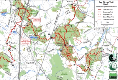 The Bay Circuit Trail in Ipswich - The Bay Circuit Trail in Ipswich enters Willowdale State Forest and continues north through the town-owned Dow-Bull Brook preservation land. A branch continues from Willowdale through Bradley Palmer S.P to New England Biolabs.… Continue reading The Bay Circuit Trail in Ipswich
 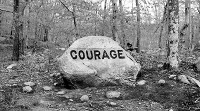 Dogtown, its History and Legends - Dogtown is a five square mile area of Gloucester and Rockport strewn with glacial boulders. Visitors to Dogtown find cellar holes of abandoned houses, and boulders emblazoned with inspirational messages. … Continue reading Dogtown, its History and Legends